We’ve been getting these key details about Greenland’s melting all wrong

We’ve been getting these key details about Greenland’s melting all wrong
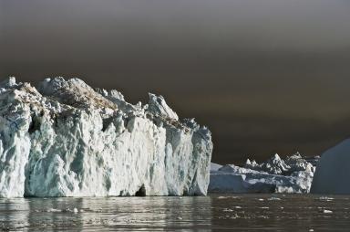
DENMARK – MAY 05: Iceberg detached from Jakobshavn (Sermeq Kujalleq) glacier, Ilulissat village, Qaasuitsup, west Greenland, Denmark. (Photo by DeAgostini/Getty Images)
Ice melt in Greenland is one of the biggest preoccupations for climate scientists today, mostly because of the ice sheet’s potential contributions to sea-level rise. But there’s still a lot we don’t know about the processes that contribute to melting, how they interact with one another and how fast they work. Now, researchers say they’ve collected new data in Greenland that reveals how wrong some assumptions about the ice sheet have been — and the new information could fundamentally change our understanding of how future climate change may affect the ice.
The new research , which was published last week in the journal Geophysical Research Letters, focuses on a field of study known as “bathymetry” — basically, the study of underwater topography, or what the floor of a body of water looks like. Bathymetry studies are important because they help scientists understand how the ocean interacts with glaciers — and that’s important because these interactions are increasingly believed to be critical processes affecting ice loss, in Greenland and elsewhere.
“We know a lot of the mass loss of the glaciers is due to melting at the glacier front,” said Martin Truffer , a physics professor and glacier expert at the University of Alaska Fairbanks, who was not involved with the new research. “And that melting happens because warm water can get right up to the ice and melt it that way.”
It’s also believed that warm ocean water can help destabilize glaciers from the bottom up, melting the ice where it’s grounded to the seafloor and eventually causing large chunks to break away.
Truffer pointed out that it’s “only in the last 10-plus years that people really started realizing how much of a role melting by ocean water played.” So scientists are still getting a handle on the kinds of information we need to really understand the process. And one under-studied part of the picture is underwater topography.
Glaciers have a tendency to affect their surrounding environment in significant ways, by eroding the landscape and cutting fjords, or narrow inlets, into the coastline. These fjords fill up with water, and the deeper they are, the more warm ocean water can get in and have contact with the glacier. Having accurate data on the locations, depths and water temperatures of these features can help scientists figure out which glaciers might be more vulnerable to melt and can even help inform the models researchers use to predict future ice loss.
The problem is that there’s been very little data collected on this front, said Eric Rignot , a University of California Irvine glaciologist and senior research scientist at NASA’s Jet Propulsion Laboratory, who led the new study.
“The fjords are vastly unmapped, and we don’t have historical data on ocean temperature in the fjords,” he said. “The waters we have to navigate are a little bit treacherous because of the presence of icebergs. And also…there’s not been a very focused scientific interest in these fjords in the past.”
As a result, published bathymetric maps of the Arctic — notably, the International Bathymetric Chart of the Arctic Ocean , which is a collaborative effort among institutions around the world — tend to estimate the depths of glacial fjords based on the data collected closest to the coastline, Truffer said.
So Rignot and an international team of researchers took it upon themselves to map out 14 glacial fjords in West Greenland, north of the famous Ilulissat Glacier. At various points between 2007 and 2014, they measured temperature and depth in these fjords and used sonar to map out underwater topographic features. They found that the actual seafloor depths were anywhere from 100 to 1,000 meters deeper than what was previously suggested by the charts.
“We knew the prior bathymetric maps were wrong, and this paper shows just how far they were wrong,” said Ian Joughin , a glacier expert at the University of Washington, by email.
The new measurements represent “a game changer for looking at the interaction of ice and ocean,” Rignot said. “One of the reasons it makes a difference is that the warm water — which you don’t find at the surface in Greenland, but several hundred meters below — has much easier access to the glaciers than would be represented in past charts.”
This could be a big deal when it comes modeling studies of Greenland’s glaciers, which rely on the best available data in order to give scientists an accurate look at how the ice might react to its environment in the future. “Without this bathymetric data there’s no way the models can represent the interaction of ice and ocean correctly,” Rignot said.
Notably, though, the study also suggests that there are much more complex factors at work when it comes to ice loss in Greenland. While ocean-ice interactions are now believed to be one of the dominant processes affecting the glaciers, the new study indicated that there’s not always a direct correlation between how much warm water is hitting the ice and how quickly a glacier is retreating.
“Given that the community has long assumed that the warm water was reaching these glaciers, the authors seem to show that the glaciers are less vulnerable to warm water than expected,” Joughin said.
After comparing the new bathymetric data with knowledge of how glaciers in the region have changed over the years, the research found some glaciers standing in warm Atlantic water had not retreated at all in the past few decades, while other glaciers grounded in shallow, cold water had retreated significantly. Other factors, such as mechanical instabilities or weaknesses in the ice, which may differ from one glacier to the next, are likely at play in these kinds of cases.
But the collection of accurate fjord measurements is still among the biggest priorities for modern-day glaciology. In fact, an ongoing NASA mission is addressing that very issue. The Oceans Melting Greenland , or OMG, mission kicked off last April with the goal of measuring ocean temperatures and modeling the shape and depth of the seafloor in Greenland to help scientists better understand the role the ocean plays in the melting of the ice sheet.
“OMG will basically extend the type of mapping we did in these two fjord systems to pretty much all the large-scale systems in Greenland,” Rignot said. So soon scientists may have accurate data for most of the ice sheet.
It’s an endeavor that highlights a critical area of science many people may think has already been completely covered, Truffer said.
“Nowadays, we think that mapping is not really an issue anymore — we’ve mapped the Earth,” he said. “But clearly, there are fairly large areas that we have really no clear idea about what the map of the bottom of the ocean there looks like. That’s quite astonishing.”
---------
Chelsea Harvey is a freelance journalist covering science. She specializes in environmental health and policy.
Tags
Who is online


70 visitors
This article expands on a previous seed I posted about Greenland ice :
Geologists have deduced that mountain glaciers moving toward the coast, cut the fjords. This occurred about 100,000 to 10,000 years ago when much of the earth's fresh water was trapped in the giant continental glaciers that were about a mile thick, lowering the sea level around 200'.
The rest of the article is interesting and likely very accurate, but that one little piece of information is crucial to understanding the formation of the fjords. Sea levels were lower, which enabled the glaciers to cut out the fjords. I'm sure that warming sea water, going up under the ice shelf today, increases melting... That makes sense, to me. The water is warmer, because the overall temperature of the earth is warmer, heating the water. Even small increases in the temperature of the air can elevate the sea water a small amount, which could tip the balance in favor of more melting.
And then more and more and more melting, raising the levels of the sea around the world. This is more dangerous, especially to low lying coastal areas, because just like ice melting in Antarctica, a lot of the ice melting is or was sitting on dry land, so it contributes to an increase in sea level by adding water to the sea, unlike ice melting at the North pole where there was no land underneath so the effect was much like an ice cube melting in the glass of water not raising the water level.
unlike ice melting at the North pole where there was no land underneath so the effect was much like an ice cube melting in the glass of water not raising the water level.
That is accurate BUT Greenland has a glacier on top of dry land . Any melting there can contribute to sea level rise .
I was referring to Greenland as that was the subject of the article. I'll be more specific next time. Sorry.
No need to apologize . The issue of Greenland glacier melt is important to the topic of sea level but not nearly as important as is the Antarctic . There melting is caused by volcanic action . Co2 ? No noticeable effect .
Thanks for adding your observation Dowser . Please see my previous seed on Greenland ice for other effects .
because the overall temperature of the earth is warmer, heating the water
What time frame are you comparing to ?
Thanks, Petey! I'll check it out!
You mean I'm being premature in buying up Greenland property to start a banana and pineapple farm?
I understand there are early opportunities in Nevada to buy oceanfront property when Calif breaks off into the Pacific ...
It's okay, Superman stopped that from happening.
And we are forever grateful out here, even though as part of the new West coast my property value would skyrocket!
I still have all the documents from my business plan to open dory tours of New York. It was set to open in 2005 which was based upon the latest scientific research done in 1990. WE chose Dory's cause we couldn't figure a way to fix the bus's and trams to float.
Predictions were that the streets of NY were going to be 15 feet underwater. We even had made arrangements to fund diving tours for those that like their air bottled.
Alas, The environment didn't cooperate.
There was no way to go back on the scientists though, they said that they now have better information, and that their previous predictions were based upon faulty data.
Still waiting, we shelved the project.
I wonder, would YOU invest in my company now that we KNOW FOR SURE that NY will be 15 feet under water?
If you can find what "brilliant" scientists were responsible for that prediction I would love to see those details ...
Don't appreciate satire much......
Still waiting, we shelved the project.
Hold on to it. The scientists were off on their timing, but it is coming. The ice melt at the North pole and arctic circle is bad, mostly for wild life such as Polar Bear. However it did not raise the sea levels. As the world warms (which it is doing for whatever reason, man made or not and I'm not going to argue that part) the ice melt from ice that has been over dry land, such as Greenland and Antarctica) will raise the sea level significantly. Don't sell your dories yet or buy any beach front property anywhere.
As the world warms (which it is doing for whatever reason
Well ... the warming has been on hold for about 20 years so don't hold your breath . You don't want to turn blue .