The polar vortex is splitting in two, which may lead to weeks of wild winter weather


A dramatic spike in temperatures is occurring at high altitudes above the North Pole, where the air is thin and typically frigid. Known as a sudden stratospheric warming event, experts say it's likely to have potentially significant repercussions for winter weather across the Northern Hemisphere for weeks to possibly months.
 Powered by Microsoft News

This unusually strong event may have profound influences on the weather in the United States and Europe, possibly increasing the potential for paralyzing snowstorms and punishing blasts of Arctic air, with the odds of the most severe cold outbreaks highest in Northern Europe. The United States is slightly more of a winter wild card for now, experts say, with individual winter storms tough to predict beyond a few days in advance.
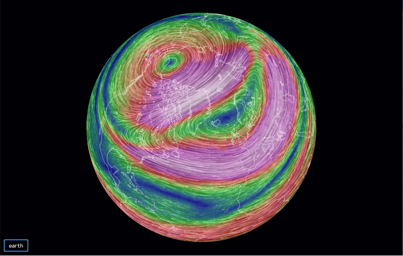
While occurring about 18 miles high in the sky and disconnected from the weather on the ground, stratospheric warming events can affect the polar vortex, which is a circulation of air around low pressure that acts as a repository for some of the coldest air on the planet.
Weather pattern is improving for snow in D.C., but beware of the hype
If the polar vortex is strong and stable, as it was last winter, that cold air will stay bottled up over the Arctic, and snow chances may be few and far between for regions such as the Mid-Atlantic and Northeast.
But when the polar vortex weakens and wobbles off the pole, pieces of it can split off and swirl southward, affecting the United States, Europe and Asia. And that's exactly what's begun to happen, due in large part to this stratospheric temperature spike.
Predicting how the vortex split will affect our weather
To accurately forecast how winter weather may soon unfold in the United States and elsewhere, seasonal forecasters like Judah Cohen of Atmospheric and Environmental Research in Massachusetts are trying to figure out how the events in the stratosphere will ripple back downward into the troposphere, the layer of the atmosphere where most weather occurs.
Stratospheric warming events are a known, but not guaranteed, trigger for knocking the polar vortex off balance, like flicking a spinning top, forcing it to spin more slowly and erratically. They are triggered by an upward flow of energy in the form of "large-scale atmospheric waves" from the lower atmosphere, according to Amy Butler, a research scientist at the National Oceanic and Atmospheric Administration's Chemical Sciences Laboratory.
© Ian Livingston/FTWP The Capitol and grounds draped in snow on Feb. 6, 2010. (Ian Livingston/The Washington Post)
Now, the stratosphere stands poised to transfer energy via downward-moving atmospheric waves into the lower atmosphere, where it can help determine which areas get buried in blizzards while others see unusually mild conditions.
Normally, winds in the stratosphere circulate from west to east around the North Pole, around an area of low pressure. But the rapid warming — on the order of 30 degrees Celsius in the past two weeks — taking place in the frigid, darkened Arctic is causing that low-pressure area to break down and the winds to slacken, Butler says. The winds are even poised to reverse, which can increase the chances of stratospheric weather affecting conditions in the lower atmosphere.
The polar vortex is synonymous with extreme cold and snow. Pieces of the vortex broke off and swirled southward during the infamous winter of 2013-14, when Chicago turned into "Chiberia" and heavy snow fell from Washington to Boston. Similar events occurred during the winter of 2009-10, which was D.C.'s snowiest on record.
A frigid air mass in Mongolia may have just crushed a world record for surface air pressure
So the news that the bone-chilling lobes of ultracold air may soon be on the march again may be cause for concern for anyone worried about a harsh winter in the United States and Europe in particular. This is especially the case this year given the challenges posed by the ongoing pandemic and demonstrated ability of the coronavirus to spread readily in indoor settings.
Significant forecast challenges
But it's quite a leap to go from the stratosphere to conditions at ground level, and Cohen, for example, argues that regardless of how impressive the stratospheric warming or polar vortex movement is, "No one is going to care until there is snow in people's backyards."
Because this sudden stratospheric warming event is so intense, there's a greater chance it will affect the polar vortex, but the precise connections between the stratosphere and troposphere are still not well understood. For example, a relatively strong stratospheric warming event last winter never knocked the polar vortex off-kilter, Cohen noted.
Sudden stratospheric warming events happen about six times per decade on average, but this event is unusually intense.
Cohen and other experts are predicting the stratospheric warming event and other conditions to result in a split polar vortex, with one center over Eurasia, and another vortex, known as a "sister vortex," swirling elsewhere. Polar vortex splits are distinct from vortex displacements, which involve shifting the bulk of the vortex southward, away from the pole, and parking it over one unfortunate spot on the globe.
Polar vortex splits that are initiated by events in Siberia tend to be more complicated, Cohen said, with fewer guarantees of major cold and snow in the Eastern United States. However, snow lovers have plenty of reasons to be optimistic.
Periods from two weeks to potentially a month or more after a sudden stratospheric warming event tend to favor negative phases of the Arctic and North Atlantic Oscillations, according to Cohen and Butler. These are measures of the air pressure differences between the Arctic and Atlantic, and negative phases of these cycles favors more frequent cold and stormy conditions in the Mid-Atlantic and Northeast as well as Northern Europe and East Asia, provided all other ingredients come together just right.
Cohen says a polar vortex split tends to favor colder than average conditions in Europe, rather than the United States, but that does not mean there won't be major snowstorms in the United States.
"I do think polar vortex splits favor big snowstorms," Cohen said, mentioning winters that brought classic nor'easters to the Mid-Atlantic and Northeast, such as the winter of 2009-10, 1978, 2013 and 2003. He cautions, however, that "every event is different."
"This is not Oprah with cars," he said. "This is not cold for everybody and snow for everybody."
"Some key things that I look at in terms of how the weather will evolve after the event: are the weather patterns going into the event more likely to be amplified by the changes in the stratosphere, or will they conflict and cancel out any stratospheric influence?" Butler, who studies the stratosphere, said in an email. "And, how strong is the deceleration of winds in the lower stratosphere?"
According to Cohen, one argument in favor of a prolonged bout of a negative Arctic Oscillation and North Atlantic Oscillation is that they've been in a negative phase going into the stratospheric warming event, which means this configuration is likely to be bolstered rather than counteracted.
Butler said there's active research into the ties between sudden stratospheric warming events and weather patterns, including the question of why only some warming episodes result in clear and long-lasting influences. Also up for debate are the ties between these occurrences and extreme events, where more research is needed.
Slower-moving storms?
Projection from the European model showing unusually mild conditions across Greenland and eastern Canada on Jan. 10, as cold and stormy conditions grip parts of Europe and the United States. (Weatherbell.com)
Michael Ventrice, a meteorologist at the Weather Company, said sudden stratospheric warming events, by favoring zones of high pressure at the high latitudes and the negative phases of the Arctic and North Atlantic Oscillations, can encourage what are known as blocking patterns. These blocks tend to slow down the jet stream, a river of air that steers weather systems along.
When blocking develops, the jet stream, driven by the temperature contrast between the equator and pole, slows in response to unusually mild conditions that evolve over the Arctic, especially eastern Canada.
Typically, the jet stream reaches its peak intensity in January, but blocking can impede this and force it to buckle more frequently while spinning up more slow-moving weather systems.
"We could have a January background state that certainly supports snows, but a jet stream that's more like March," he said. "I think the potential is there for slow-moving storms."
Ventrice, for his part, sees the potential for transient North Atlantic blocking conditions, based on an examination of past sudden stratospheric warming events that began in Siberia.
This means the next several weeks at least could bring periods when conditions would favor snowstorms along the Eastern Seaboard, mixed with periods of at least several days when the most important ingredients would be missing. That's a recipe for anxiety among East Coast snow lovers, but also some hope after a record snowless winter in the Mid-Atlantic and parts of New England last year.
Continue ReadingShow full articles without "Continue Reading" button for {0} hours. Microsoft may earn an Affiliate Commission if you purchase something through recommended links in this article.

Tags
Who is online


475 visitors
Average or slightly above average temperatures are predicted for Chicago through mid January. That will put us halfway through the winter having had very few days of really cold temperatures. I'll take it. Hasnt been much snow either.
I hate winter
I love winter, just not to extreme degrees.
I know you were stationed in Alaska, but were you stationed at any other cold weather base? Alaska was my only one, but it would get downright frigid in Lubbock, TX. Everybody thought I should be able to handle winter considering I grew up in Western PA and was stationed in Alaska for 3 years...but nope. Still can't stand it. The only good thing about snow is skiing