Biggest snowstorm in two years possible for New York as Northeast braces for snow
Category: News & Politics
Via: perrie-halpern • last year • 14 commentsBy: Kathryn Prociv, Steve Strouss and Antonio Planas

Over the weekend, while millions were watching the big game, meteorologists were watching a trend in the forecast models signaling increasing odds for an impactful winter storm for the Northeast, including snow-starved New York City.
A colder and more southern shift to the storm's track is what captured forecasters' attention, increasing the likelihood for plowable snow from Philadelphia to Providence, Rhode Island. The southern shift in the models painted the picture of a narrow axis of heavier snow inching closer to the Interstate 95 corridor.
Of even greater concern, the timing of the heaviest snow was forecast to align with Tuesday morning's rush hour. The potential for snowfall rates of 2 inches per hour combined with the prime commute time could cause major travel delays on the road and at the major airports from Philadelphia to Newark, New Jersey, and New York to Boston.
By Monday morning, 49 million people were already under winter alerts stretching from parts of the central Plains and the Midwest into the Northeast and New England.
Snow is expected to fall across parts of eastern Oklahoma, southern Missouri, parts of Arkansas, western Tennessee and southern Kentucky on Monday. At the same time, cold rain will move up through the mid-Atlantic and into the Northeast by the evening.
Monday night into Tuesday morning is when rain will change to snow across the Northeast, including along the I-95 corridor from Philadelphia to Hartford, Connecticut.
On Tuesday, rain is expected to switch to snow shortly before sunrise, with snow falling at 1 to 2 inches per hour during the morning commute along the I-95 corridor from Philadelphia to Hartford and Providence.
Even heavier snow with potential rates of 2 to 3 inches per hour will be possible across eastern Pennsylvania, northern New Jersey, the Hudson Valley and up through northern Connecticut and Rhode Island.
Because of the strong dynamics associated with the system, some thundersnow will be possible around sunrise coinciding with the areas of highest snowfall rates. New York City is in the zone for potential thundersnow.
Strong winds gusting in the 25 to 35 mph range will lead to low visibility and worsen heavy travel delays.
It will be a fast-moving storm, so all snow will be off the Atlantic coast by 5 p.m. Tuesday.
Widespread snow of 3 to 6 inches will be possible across most of the Northeast and New England. A ribbon of 6 to 12 inches of snow looks likely in a narrow band somewhere from northern New Jersey to eastern Massachusetts. Forecasters stressed that while it is difficult to predict the precise location where the band of heaviest snow will set up, what snow does fall is likely to be very heavy and wet. The heavy snow could increase the likelihood for power outages and be dangerous for shoveling.
City timing and expected snowfall totals
Philadelphia can expect the rain to begin after 8 p.m. Monday, then change to snow around 7 a.m. Tuesday. By the time the snow is expected to end around the lunch hour, snowfall totals could be 1 to3 inches.
New York City's rain will begin a bit later than Philadelphia's, around 11 p.m. Monday, with the changeover to snow occurring around 7 a.m. Tuesday. When the snow ends around midafternoon, 3 to 6 inches could blanket Central Park. New York City is in the zone of greatest uncertainty depending on where the heaviest snow band sets up, so the range of snowfall possibilities may be adjusted as the forecast comes into better focus Monday.
If New York City picks up 6 inches or more from this storm, it will be the city's largest snowstorm in two years — since January 2022.
Mayor Eric Adams announced Monday morning that public schools would move to remote learning Tuesday.
Boston will be the last of the big cities along the I-95 corridor to get precipitation. It will begin as a rain-and-snow mix around 4 a.m. Tuesday; then it will become all snow by 7 a.m. Three to 6 inches of snow will be possible by the time it wraps up.
The potential for heavy snow prompted school districts and municipalities to respond. Patterson public schools in New Jersey said schools and district offices would be closed Tuesday.
Similarly, Boston Public Schools also announced all district buildings would be closed Tuesday.
Westchester County, New York, Executive George Latimer declared a state of emergency beginning at 10 p.m. Monday to "ensure the safety and well-being of the residents," according to a statement.
If the colder and snowier southerly trend continues, the snow scenarios may go up throughout Monday to reflect the change in storm track and intensity.
While all eyes are on the northern side of the storm system, the southern side will also bring a nasty combination of severe thunderstorms and flooding rainfall to the Southeast on Monday.
Already by Monday morning, severe thunderstorms were charging across parts of the South and Gulf Coast states, with a tornado watch in effect until 10 a.m. for parts of Louisiana, Mississippi, Alabama and the Florida Panhandle.
By Monday afternoon, heavy rain was dousing areas in Alabama, Georgia, Tennessee, South Carolina and North Carolina.
Two million people were at risk for severe storms capable of hail, high winds and isolated tornadoes.
In addition to the severe storms, flooding will also be a concern. About16 million people were under flood alerts across the Southeast.

Tags
Who is online


73 visitors
The storm is shifting which will spare a lot of New England. I heard one meteorologist call it a tricky storm. I felt a little self-conscious.
Scary.
lol …. Slow news day
it's east coast bias in the news media
Do you think there would ever be a national news story about 6 inches of snow in Michigan? A lot of the national news reporters and anchors are based in New York and they think that is the center of the weather universe.
Nope, six inches is a regular accumulation in Northern Michigan. Although weather reporting has gotten sensationalized everywhere over the years. You know they name winter storms now like they do hurricanes right?
Crazy.
They do this to make every snow a type of "extreme" occurrence. When TWC started doing this, I started watching other weather reports, because they were naming Alberta Clippers as if they were akin to a hurricane when they were only just a short lived annoyance.
If they were reporting like this is the late 70’s, early 80’s for the Upper Peninsula they would have run out of letters. My freshman year up there we set a total snow accumulation record of like 390”.
Yep, that’s over 30 feet of snow.
Be careful North Easterners
Just a dusting in the Shenandoah Valley
Supposed to get to the low 50's here in Denver, which help melt the 5 inches we got over the weekend.
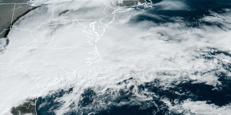
Here's a satellite feed that shows the whole US and how chaotic the atmosphere gets in an active pattern.
14 inches of heavy wet snow in our town in CT. I took pity on a couple neighbors who were shoveling. Perfect weather for a snowblower and snowman. I have a couple snowballs ready for when my wife comes outside, heh heh heh
Nice. We call that heart attack snow for us old geezers. Don’t know if you are one of those but be careful if you are.
Getting there, that is why I bought a snowblower a couple years ago. Our new neighbors from Louisiana and Carolina didn't think they needed them. I think they are going out to buy them tomorrow.
No snow here. There are just a few ice mounds where the "snow banks" used to be. Looks like April around these parts. Not that I'm complaining...