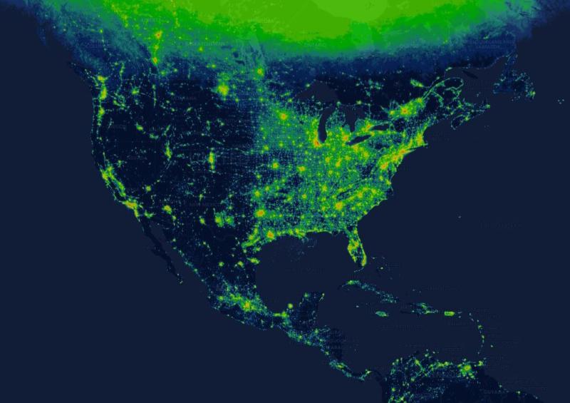
New interactive map shows how light pollution affects your hometown


Scientists track pollution in the air as well as in the world’s oceans, lakes and rivers. And now, there's a simple interactive tool that affords a detailed look at pollution of a different kind: artificial light.
The Radiance Light Trends website , which went live last week, presents a world map that shows where night skies are still relatively dark and where there are hot spots — areas where the blues and black indicating darkness are replaced by greens, yellows and reds indicating the glow of artificial light at night.
“The map shows light emissions on Earth, specifically on clear nights, because that’s when satellites can look down and see all the way to the ground,” said Christopher Kyba, a physicist at the German Research Centre for Geosciences in Potsdam who coordinated the effort to build the website.
Artificial light disrupts the behavior of plants and animals, which evolved in a world without light from buildings, streetlights and other sources. In addition, light pollution has been linked to health problems in humans, including sleep disorders and obesity.
Artificial light also makes life hard for skywatchers and astronomers , who need dark skies in order to make detailed observations of the heavens.
The website, created as part of a European Union-funded project known as GEOEssential, allows users to zoom in on specific regions and go back in time to see how light emissions in a particular area have changed in recent decades. The map features roads, cities and other landmarks that make it easy to find specific locations.
Kyba wanted the tool to be useful for both scientists and the general public. “A lot of satellite data is released for free online to everybody, but just because it’s free doesn’t mean it’s accessible,” he said. “The idea is to give this tool to everyone, so that everyone in the world has access to this data.”
The map incorporates data from now-decommissioned spy satellites that operated from 1992 to 2013. The Suomi National Polar-orbiting Partnership satellite, jointly operated by NASA and the National Oceanic and Atmospheric Administration, is the source of data from 2012 to the present day. The map updates automatically each time new satellite imagery is obtained.
Kyba uses the website as part of an effort to understand how artificial light and "skyglow" produced by cities is changing. He’s planning to make the website’s code available free of charge so similar tools can be made using different data sets from satellites.
“You could do something with sea ice or atmospheric temperatures , or the data about when trees get their leaves,” Kyba said. “For any satellite dataset you can imagine, you could produce a similar system to look at trends over time, so I hope that other people will adapt this for their own uses.”
Tags
Who is online
40 visitors

I spent some time on the interactive map and it confirmed what I thought. I was in one of the few areas of Long Island with minimal light pollution. Great for me when I want to take out my telescope; not so great for driving.
How about where you live?
It's black out here on the prairie but in reality, towns 60 miles away provide plenty of light pollution that limit my viewing angles when I schlep out the Celestron Newtonian. It's still plenty dark enough for good meteor shower viewing however.
I live in a small town in the Sonoran Desert on the AZ/Mexico border, (population 13,000) the light signature is relatively light. Go about 5 miles in any direction East, West, or North and you have near perfect star gazing conditions.
I don't know if I'm looking at this right, but where I live (small town in Central Arkansas) there's a lot of yellow and orange. No wonder I can't see many stars at night.
I zoomed in over my road and it's more green than yellow or orange. Is that a better color?
I agree TG, the entirety of central and northern Canada, which I assure you gets very dark and is great for stargazing is covered in a green hue. For my area I'm thinking they've combined multiple years of data and since in the summer night is very short we ended up being classified as having light pollution.
Wonder if the Northern lights have an effect.
Could be I suppose but despite the fact the we see them more often than people in the southern latitudes they still don't happen all that regularly
Not sure about the Northern Lights, but I have seen the Southern Lights in Antarctica and they do on occasion make a difference.
Yes, the greener the color the less the light pollution. Black is the best, but you would have to be living alone in a cabin living off of fire, LOL!
That must be why The Congo is such a picture of health........Or North Korea.
Pretty sure that there are a plethora of factors involved in a region's health score.
Sure. I’ve worked nights for 24 years, so I’m very aware of the problems with artificial light. But, I’ll take the light pollution any day over the alternative. Look at the map and start looking up life expectancies for those countries without a lot of light pollution.
Light pollution means infrastructure, clean water, hospitals, reliable food supply, heat and security.
Light pollution is just but one factor. Basic medical and food needs usually are more important.
Nice! My neck of the woods has minimal light pollution once ten - twenty miles outside of the main city.
Best low light pollution i've every seen is on a float out in the middle of the Pacific, running in blackout conditions. I'd sneak out there whenever i could and scam a spotting scope to look at the moon or just stargaze. The detail you could see on the moon is really incredible.
I even found the six pack of Dos Equis the Mexicans left up there.
Looking at the stars in a perfect location is amazing. It's one of my favorite things to do in the warmer weather.
What is also amazing is how many stars there really are up there. Until you get in a really low ambient light situation you can't really see it for what it is. Its almost like there are more stars up there than there is space.
If you can try stargazing using NVG's you see way more stars than with the naked eye (admittedly everything will have a slightly greenish hue)
Kind of a dumb question, but where is the interactive map?
Radiance Light Trends website
Thanks.
I am in a dark orange colour.
From our courtyard, we can't see much of anything. If we go two or three miles, and keep our backs turned to the agglomeration, the sky's pretty nice.
But to really get away from the light, we must go over the Foothills in the the valley on the other side. That's an expedition...
We are in a small city, population 55K but there are numerous farms and ranches so we do get some beautiful star lite nights.