Crazy weather phenomena in our lives...
Category: News & Politics
Via: msaubrey-aka-ahyoka • 3 years ago • 24 commentsBy: National Weather Service
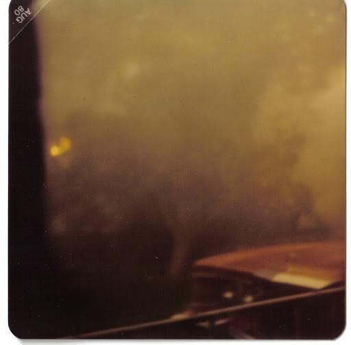
Despite the fact that I was only about 1.5 years old when the derecho "green storm" of southeast MI hit, I remember it quite vividly. I even verified my memory with my parents. I remember being outside on that warm July day and being in my dad's arms when the sky turned a pea-soup green. It was still rather calm at the moment, but my mother was screaming at us from the basement. We even had a cable guy over installing cable. My mom brought my little potty to the basement in case she had to go. It got really ugly, really fast. At that time, we lived in a house that had a quarry [with forestry around] to the south of us and a large field and a steel mill to the east of us. We only had one direct neighbor. Somehow there was little damage to our house even though there were "branches" flying about... more like half trees rather than branches. My parents couldn't believe that I remembered that event and to that level of detail. It's funny... the things you may or may not remember from childhood; more specifically before the age of 5.
There was a time that I was driving one of our main roads and drove by my great aunt Pearl's house. I called my mom when I got home and asked, "Wasn't there a greenhouse built off the side of Aunt Pearl's house at one time? I remember being in her house, smelling damp soil all the time." My mom said, "Oh my God. I can't believe you remember that! Yeah, it was full of plants, but the greenhouse, which was part of the house was torn down by the next owners."
Too bad I wasn't around during the snow storm of 78. That would have been something to see. https://www.detroitnews.com/story/news/local/michigan-history/2018/01/25/michigan-historic-snowstorm/109820860/
Other links and "fun facts" about derechos:
Specific to southeast MI in 1980 - http://www.downriverthings.com/derecho-green-storm-of-1980.html
General facts - https://www.mentalfloss.com/article/502382/9-powerful-facts-about-derechos
What are some crazy weather phenomena that has occurred in your lifetime?

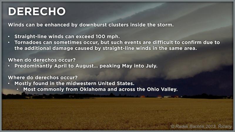
The word "derecho" may sound unfamiliar or its use in meteorology relatively recent in nature, but the word actually was brought into meteorological vernacular way back in 1888. Dr. Gustavus Hinrichs, a physics professor at the University of Iowa, was given that credit when he used the word, derecho, in a paper he had published in the American Meteorological Journal in 1888. Dr Hinrichs chose this terminology for thunderstorm induced straight-line winds as an analog to the word tornado. Derecho is a Spanish word which can be defined as "direct" or "straight ahead" while tornado is thought by some, including Dr. Hinrichs, to have been derived from the Spanish word "tornar" which means "to turn". This definition and other derecho facts are taken from the Storm Prediction Center's About Derechos web page, which contains many interesting facts and background studies about derechos.
Even though the term "derecho" dates back well over a century, it has only been relatively recent (since the 1980s) that more investigative studies and research has greatly increased our knowledge about these types of storms. Derechos are associated with a line of showers or thunderstorms that are often "curved" in shape on radar and satellite. These bowed out storms are called " bow echoes ". A derecho can be associated with a single bow echo or multiple bow echoes. By definition winds in a derecho must meet the National Weather Service criterion for severe wind gusts (greater than 57 mph) at most points along the derecho path. In the stronger derecho events winds can exceed 100 mph.
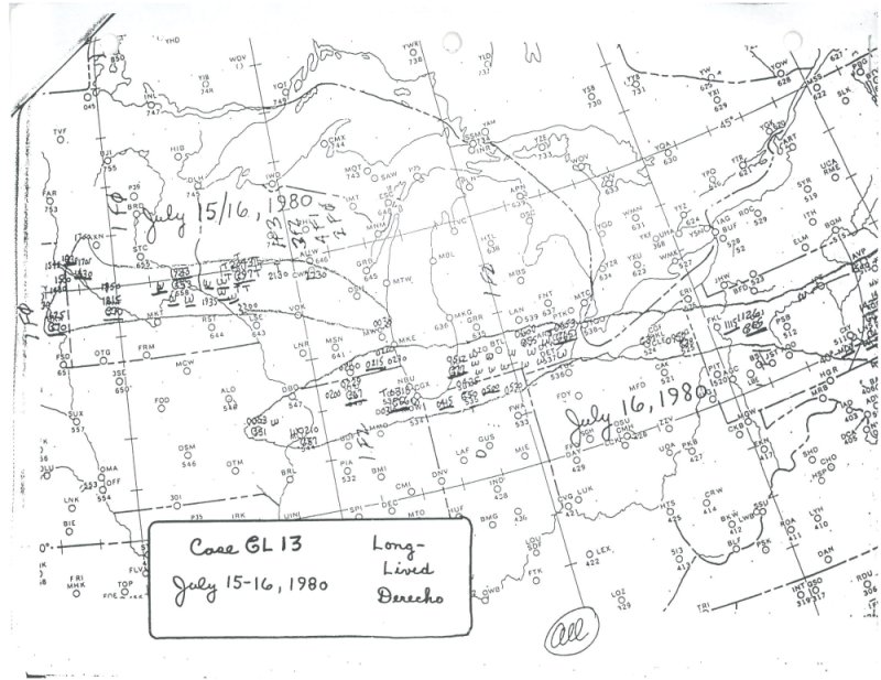
Southeast Lower Michigan has had several derechos in the past, but certainly one of the more memorable ones plowed through extreme Southern Michigan during the forenoon hours of Wednesday, July 16th, 1980.
Summer of '80 starts out on a chilly note
The Summer of 1980 actually hadn't been much of a summer as far as warm temperatures and dry weather were concerned. The summer had been unseasonably cool and soggy into early July. June's average temperature was a relatively chilly 63.7 degrees, making it the eighth coolest June on record at Detroit. To add insult to injury, not only had June been cool, it also had been very wet. June's monthly rainfall totaled up to nearly six and a half inches /6.42"/, making it the sixth wettest June on record, which undoubtedly made the month seem even worse.
While the first few weeks of July averaged a bit below normal, some good ole' fashion summer-time heat finally began to bubble up into the region by mid month. Hot and unstable air pushed its way north into the Great Lakes by the 15th as temperatures surged into the lower to mid 90s. Up until that time, only once before had temperatures pushed up into the 90s that summer. The arrival of the hot and humid air mass set off some scattered showers and thunderstorms on the 15th, but really nothing of consequence compared to what would generate to the west overnight.
Birth of a Hybrid Derecho
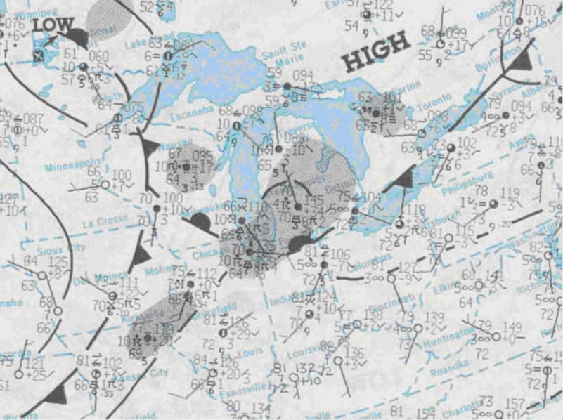 A low pressure area with attending warm and cold fronts ( map-2 ) pushing through the Upper Midwest was responsible in igniting the derecho at the surface late on the 15th. Thunderstorms developing over extreme Eastern Iowa and Northern Illinois during the very early morning hours of the 16th, intensified and formed into a squall line that pushed through Northern Illinois between 3 AM and 5 AM EDT. The storms were spawned out ahead of the frontal system as it approached northern Illinois, mainly ahead of the triple point juncture and nearly perpendicular to the warm front. At the same time, a potent mid level short wave ( map-3 ) and wind max (approx 60-70 knots) surged east across the Upper Midwest toward the Southern Great Lakes.
Nice and Bright to Black as Night
The derecho surged quickly east across Northern Indiana and Southern Lake Michigan with a measured wind gust of 98 mph at the St. Joseph Coast Guard as it blasted onshore in Southwest Lower Michigan!
While the sky was relatively bright at sunrise over Southeast Lower Michigan, a band of foreboding clouds advanced in quickly from the west, covering the celestial dome. As the forceful storms and associated hurricane force winds approached the area, several observers remarked about the horrid dark green color the sky took on as the squall moved overhead. In fact, numerous people over the years have commented about the "dark pea green sky" that accompanied the July 16th 1980 storm. The green color in the sky may have been reflective of the low sun angle at the time (the derecho moved through region between 730 and 930 AM EDT) and abundance of moisture in the low clouds. It got so dark that many street lights were triggered and popped on over portions of the region. Severe thunderstorm warnings were issued over the region though some remarked: "it happened so quickly and early in the day, it caught us off guard".
The hardest hit regions across Southeast Lower Michigan were Washtenaw and Wayne counties, extending mainly from the Ann Arbor area east into southern sections of Detroit (or south of the Ford Road /M-153/ corridor). While the wind officially gusted to 71 mph at Detroit Metro Airport, much higher winds were reported in other areas (see storm report below) in the strongest core of the derecho.
As one person who witnessed the swath of damage across southern portions of Washtenaw and Wayne counties, the following excerpts from storm data relay the incredible outcome of the storm. In the storm data below, the derecho is referred to as a downburst. In addition, the derecho was accompanied by a small tornado as it exited extreme Southeast Lower Michigan. Tornadoes can occur in isolated thunderstorm supercells ahead of the derecho producing squall line or they may be associated with the squall line itself.
| STORM DATA | ||
| Counties in SE Mich |
Date 7/16/80 |
Time 830-920AM EDT |
| |
||
| Washtenaw Wayne Monroe |
"Intense downburst developed just west of Ann Arbor. Path of the most intense damage across southern Ann Arbor then eastward through the Downriver suburbs of Detroit. Winds estimated up to 100 mph in Washtenaw county, up to 150 mph in Wayne County. Innumerable buildings, vehicles and trees destroyed in eastern Washtenaw, central and southern Wayne, and northeastern Monroe counties. Several boats were swamped on the Detroit River. Power off in some areas up to ten days." | |
| |
||
| Downriver Communities | Date 7/16/80 |
Time 910 AM EDT |
| |
||
| Allen Park, Lincoln Park, and Ecorse, in Wayne county | "Railroad cars blown off track in both directions in Allen Park. Department store roof blown sideways in Lincoln Park. Funnel sighted over Detroit River from Canadian shore. Tornado damage included in, and hardly distinguishable from large area of straight line wind damage. Funnel continued eastward several more miles into Canada". | |
It's amazing that after reading about the force of the wind and subsequent damage, that only one person - a woman - was reported injured in sort of a freak accident when the wind forced her into a revolving door!
Note the following that was taken from " Derecho Hazards in the United States " by Walker S. Asley, Climatology Research Laboratory at the University of Georgia, Athens, Georgia. It gives an interesting account of the July 16th,1980 Derecho storm damage relative to other storm damage.
Fujita and Wakimoto (1981) provided extensive documentation of the 16 July 1980 derecho that produced widespread damage across large areas of Michigan, Illinois, Wisconsin, and Minnesota. They indicated that this storm produced approximately $650 million in damage as it traversed the four-state region. Accounting for inflation (to 2003 dollars), this storm produced an estimated $1.3 billion in damage from strictly straight-line winds. This estimate exceeds many damage tallies from U.S. hurricanes and is larger than the inflation-adjusted damage estimates from all major tornadoes that have affected the U.S. since 1890 (Brooks and Doswell 2001). This single event illustrates that derecho damage can exceed the damage from most hurricanes and tornado events affecting the contiguous U.S.
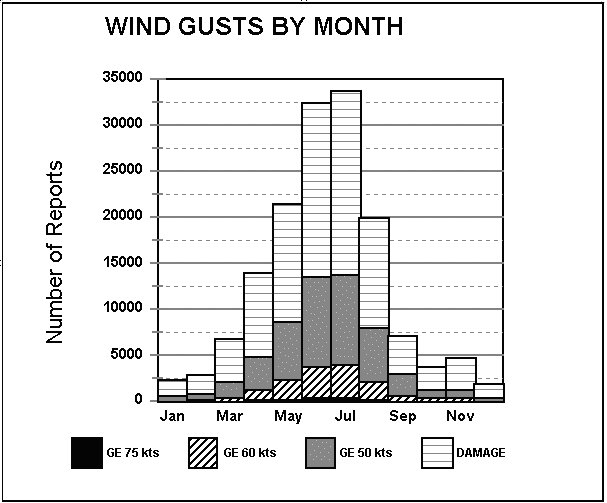 Note the graph to the right which displays monthly damaging wind events in the U.S. July and June are the top months for wind storms. Many of these wind storms occur as derechos over the Great Lakes states (Johns and Hirt, 1987).
Tags
Who is online
419 visitors

What are some crazy weather phenomena that has occurred in your lifetime?
NO POLITICS, NO PRESIDENTS PAST OR PRESENT.
Golf ball plus sized hail. When the storm was over there wasn't a leaf left in any trees around.
When I was very young, we saw a cigar front ( what my dad called it ). Looked like below picture, except we were nowhere close to any bodies of water.
When I was at McMurdo Station, Antarctica we had what were known as Nacreous Cloud formations. These were solitary globular shaped clouds in the sky during what is known as the Austral Summer months of 24 hours of daylight that actually glowed. Another freaky weather phenomena occurred when minute ice crystals floated in the air and refracted sunlight resulting in slightly golden shimmering haze in the air. First time I saw this I thought something was wrong with my eyes! These are only a few of the weird weather phenomena I experienced in four years of going to the "Ice" as we called it.
I enjoy the way you tell a story. Brings back fond memories of long ago and far away.
The strangest weather phenomena here are straight-line winds. It's like an invisible wall of air moving across the landscape that can be as damaging as tornados.
Thank you Nerm.
Those straight-line winds are considered derechos... well depending on how long they are; however, they're still considered squall lines if they're not quite derechos. They can be [and often are] far more damaging than tornados.
Colorado has a large variety of weather because of its central location and having a high mountain range to the West. The weather can vary from extend from long cold snaps in the winter to 50-60 days with highs 90 or above. Most years we can have lots of thunderstorms that form over the mountains and move out over the plains as the afternoon progresses. Some of these can be impressive. I remember a few where the lightning seemed continuous and the sound of thunder never ceased. Many years we have a pattern that develops by midsummer call the "Summer Monsoon", a seasonal flow of moist air from Mexico and Arizona that really juices up the atmosphere with moisture. Very heavy rains and hail can happen with these storms.
Quite often, there are a few days most summers here, where the atmospheric moisture if high and the upper winds are very light. When that happens, storms can simply sit and rain for hours over one spot. That happened in 1965 over the high ground South of Denver. Over a foot of rain came down in just few hours on Plum Creek which made its to the South Platte and flooded Denver, destroying all but one bridge over the Platte. I watched this storm build and grow from late morning until late afternoon...the flood came through around sundown. Lots of damage but only a few fatalities from this storm.
The really bad storm came in July of 1976. Once again about 12-14 inches of rain came down in about 4 hours on the headwaters of the Big Thompson River...near Estes Park. With very little warning many people were caught unawares and about 144 them were killed or went missing. I watched this storm grow from a small cumulus cloud over downtown Denver into a towering thunderhead in just a few hours. It then moved very slowly to the Northwest and parked over the mountains just to the East of Estes Park.
In September 2013 the Big Thompson flooded again after several days of rain. The cause this time was the remnants of a tropical storm moving in from the Southwest and meeting up an early season cold front. This system became stationary over Northern Colorado and moderate to heavy rains persisted for several days including Denver. Finally, in 1979 a three month baby girl was tragically killed by a hailstone that fractured her skull, as her mother was seeking shelter from the storm. This happened near Fort Collins
Weather around mountains can most certainly be interesting. When I was in Las Vegas for work years ago, it was August 2006 and HOT. I watched a storm form over the mountains from the Henderson Valley desert. You could see the rain pouring from a distance. It never made it past the mountain; it just sat, like you're talking about, pouring rain over one area for most of the day. I will say however, despite it never making it's way westward, it did cool things off from 127*F to 101*F... then, once the rain stopped, it warmed back up to 110*F overnight.
That is so sad! Sometimes you never know when a freak accident will occur.
The most beautiful I ever saw was a mid-winter snow thunderstorm (a snonderstorm?). The lightning reflecting off the fresh snow was amazing to watch, the cold air even changed the sound of the thunder
We call it thunder-snow here in southeast MI. It's really an interesting phenomena, isn't it? It seems to rumble for longer and deeper and the lightening for the millisecond that it flashes, it makes the snow glisten bright.
I've noticed that too. I believe it's due to the air mass being colder is denser and more reactive to the instant heat of the lightning and the snow instead of rain has a less of a muffling effect allowing the echoes of the initial strike to travel farther and return from farther away.
Yeah that's better than a snonderstorm
I remember when we had a snow storm, it was forecast to be a 1 to 2 inch accumulation. At 3:00 am I went out to check the outdoor wood furnace and the deck was dry, it started to snow before I went back inside and the deck was solid white, I checked ten minutes later and there was already 1/2 an inch, by the time my wife went to work around six there was six inches, when I left for work there was eight inches, by the time it stopped snowing around two in the afternoon there was 18 inches, this event was widely unreported and happened way back on February 9th 2021. If you went 8 miles to the south and north of us, there was just a 1/2 inch of accumulation. The very next morning it started snowing hard again, but we only got 8 inches from that one.
Wow. Don't ya love the "predictions" sometimes?
That happened here in 1997, probably end of Jan. early Feb. I was working at Pep Boys at the time, and driving a 1990 Ford Escort GT with a manual trans. The weatherman predicted a couple inches, but that was a LIE! I think while I was working that evening, it snowed a good 8" or more. I had to have someone push my car out of my parking spot and then push to get me moving forward... I didn't stop for red lights or stop signs. I figured if I were pulled over, the cop would have to push me to get me moving again. I only lived about 1/2 mile from the store, so I wasn't too worried. No one was on the roads anyways. The next morning, I awoke to there being about 15" of fresh snow. My boss, with a 4x4 picked me up to get to work.
What was really disgusting about it, the only report was a city 30 miles to the west, that happened to be at the end of the phenomenon, got 8 inches.
Our tractor that has the snow blower on it, the hydrostat filter went bad that morning and there was one 20 miles south, so I took off in my 98 Dakota in which one of the half shafts blew out a week before, therefore I didn't have FWD, went 3-1/2 miles through a foot of snow and just timed it out right that a county truck had just passed by on a state route, I made it to the city where the filter was easily from there, but noted that the further south I went the less snow until there was a 1/2 inch in the city, but I counted 4 county trucks running around spreading salt, I was like WHAT?? When I got back there was 18 inches and my truck was plowing snow over my hood and had to stop several times to clear the windshield, back up, and hit it again till I made it in. One thing you learn about FWD, it you use it and get stuck, your stuck, if you don't use it and get stuck you can still get yourself out and learn not to go any further, just turn around.
We had a small creek that ran through our yard. Probably close to 3 football fields away from the house. In 2018 we got over 9” of rain in less than 24 hours. This is a photo from my kitchen window. The creek is way down there beyond the tree line. You can just barely still see the tops of our fence posts to the left. That was a bad day!
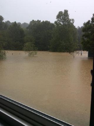
Tell me about it. May 10th 2020, it started raining here over night and continued for 24 hours, where I am we ended up with 9 inches, but as you heard from the national news, others to the west and north of us got upwards of a foot. The river north of us came out of its banks an flowed south across all the roads and fields, taking out all the roads around the bridges south and west of us to the point that to go south from here, you had to travel 100 miles out of your way.
Mother Nature can be an incredible force.
I hope the interior of your house didn't flood
Unfortunately the basement took a pretty big hit. We lost our washer, dryer, and water heater. We were in the process of getting the home ready to sell and had just put in a new furnace, thankfully it made it through.
I guess we were lucky, some people in town had to actually evacuate their homes. I felt terrible for them. We had a mess but they lost much more.