
Aerial photos uncover unique side of familiar landscapes

By: No Author Indicated

 S E E D E D C O N T E N T

Aerial photos uncover unique side of familiar landscapes

Desert poplar trees shimmer in autumn sunlight in Ejine Banner, North China's Inner Mongolia autonomous region, Oct 13, 2017. [Photo/Xinhua]
Scenery can vary a great deal when seen from different angles. This series of aerial photos taken this year by a drone includes a substantial number of snapshots from different corners and attractions around China. When seen from high above, familiar landscapes and scenic spots can transform into new sights, displaying their beauty in lines, shapes and rhythms, unraveling highly diverse scenes that we otherwise might not behold.
.

A photo taken on June 21, 2017, shows the Zhagana mountains in Diebu county, Gannan Tibetan autonomous prefecture, Northwest China's Gansu province. Zhagana is a mountainous region on the northeastern rim of the Tibetan Plateau, with an average altitude of 3,500 meters. The region has a unique cultural and natural landscape featuring Tibetan-style villages, primitive forests and mountains. [Photo/Xinhua]
.

An aerial view of Guangwu Mountain in Nanjiang county, Bazhong city, Sichuan province, Nov 2, 2017. [Photo/Xinhua]'
.

Sunset over Mazuao Bay at Nanjilie Island, Zhejiang province, July 20, 2017. [Photo/Xinhua
.

A panoramic view of the Tianqiaogou scenic area in Dandong city, Liaoning province, Oct 11, 2017. [Photo/Xinhua]
.

The enchanting autumn scenery of Kanas Lake, Northwest China's Xinjiang Uygur autonomous region, Oct 13, 2017. [Photo/Xinhua]
.

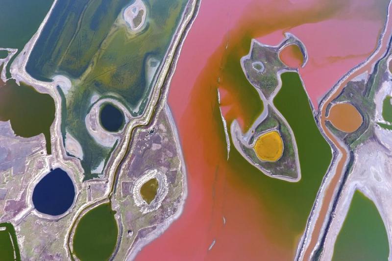
A salt lake reflects different shades of color when seen from high above the sky, Yuncheng city, Shanxi province, April 13, 2017. [Photo/Xinhua]
.

Visitors climb a staircase through the azalea flowers, Yingshan county, Huanggang city, Hubei province, April 21, 2017. [Photo/Xinhua]
.

An aerial view of Qiandao Lake, Hangzhou city, Zhejiang province, Aug 7, 2017. [Photo/Xinhua]
.

Frosted trees along the banks of the Kuerbin River, Heilongjiang province, Jan 21, 2017. [Photo/Xinhua]
The administrator of this group reserves the right, along with the site moderators, to moderate all and any postings to this group, including the right to enforce the ToS, the CoC, and also including anything that the administrator deems within his sole discretion to be offensive or off topic, with the power to delete in exercising those rights.
It would be best, therefore, to be civil in posting on this group.
By now it should be well known that I am unable to open certain videos and pictures. If I cannot, I will ask that they be described and explained. If the poster refuses to comply, their comment will be deleted. Instagrams are banned.
Tags
Who is online
84 visitors
Does anyone know what those rings in the lake are, and what they are for? As well, can anyone explain the different colours that appear on the salt lake?
Aren't those rings for oyster farming? After looking again the oyster farms are the rows arranged in rectangles and the rings more than likely for fish farming.
As for the colours, it would depend on the type of mineral salt in each of the areas.
Thanks for answering my questions. As well, it's interesting to note that the mineral makeup can vary as only parts of the general area.
Arvo....here the round rings are used for Salmon farming in Tasmania..
Or in South Australia they use them for Tuna farming...
More popular than I thought, and I never saw anything like that before.
There are salt plains in Western Australia and far as I know the different colours are to do with the different minerals as Bcc said...
But it's also to do with sediments, algae and bacteria from what I have read..
Another thing I never saw or knew about before I saw the article.